Pace Phil Spector, pace Fenway Faithful, pace Pink Floyd (we do need an education), a partial selection of After Burnham project images.
/2-01-Court of Honor and Grand Basin at The Chicago World's Columbian Exposition of 1893.jpg)
/2-02-Aerial View of Washington DC from The McMillan Plan of 1901.jpg)
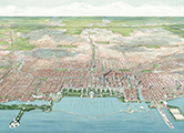
/2-03-Bird's-eye view of Metropolitan Chicago.jpg)
/2-04-Chicago as Mid-west Regional Center.jpg)
/2-04a-Proposed Roadway Connecting Towns Around Lake Michigan.jpg)
/2-05-Chicago's Radiating and Encircling Regional Thoroughfares.jpg)
/2-06-Map of Chicago's proposed System of Boulevards - Parks - Forest Preserves.jpg)
/2-07-Proposed Public Recreational Lakefront Parks from Jackson Park (south) to Wilmette (north).jpg)
/2-08-Aerial view of proposed South Shore Lagoons looking south.jpg)
/2-09-Diagram of existing 1909 industrial areas and commuter and industrial rail circuits.jpg)
/2-10-Grand Axis view looking west over Chicago's Harbor and Civic Center.jpg)
/2-11-Diagram of Street Circulation and Parks in Relation to Population Density.jpg)
/2-12-Existing and Proposed Diagonal Arteries.jpg)
/2-13-Existing and Proposed Parks and Boulevards.jpg)
/2-14-View from South Branch of The Chicago River at Wolf Point looking north.jpg)
/2-15-Comprehensive plan view of Chicago's Central Area.jpg)
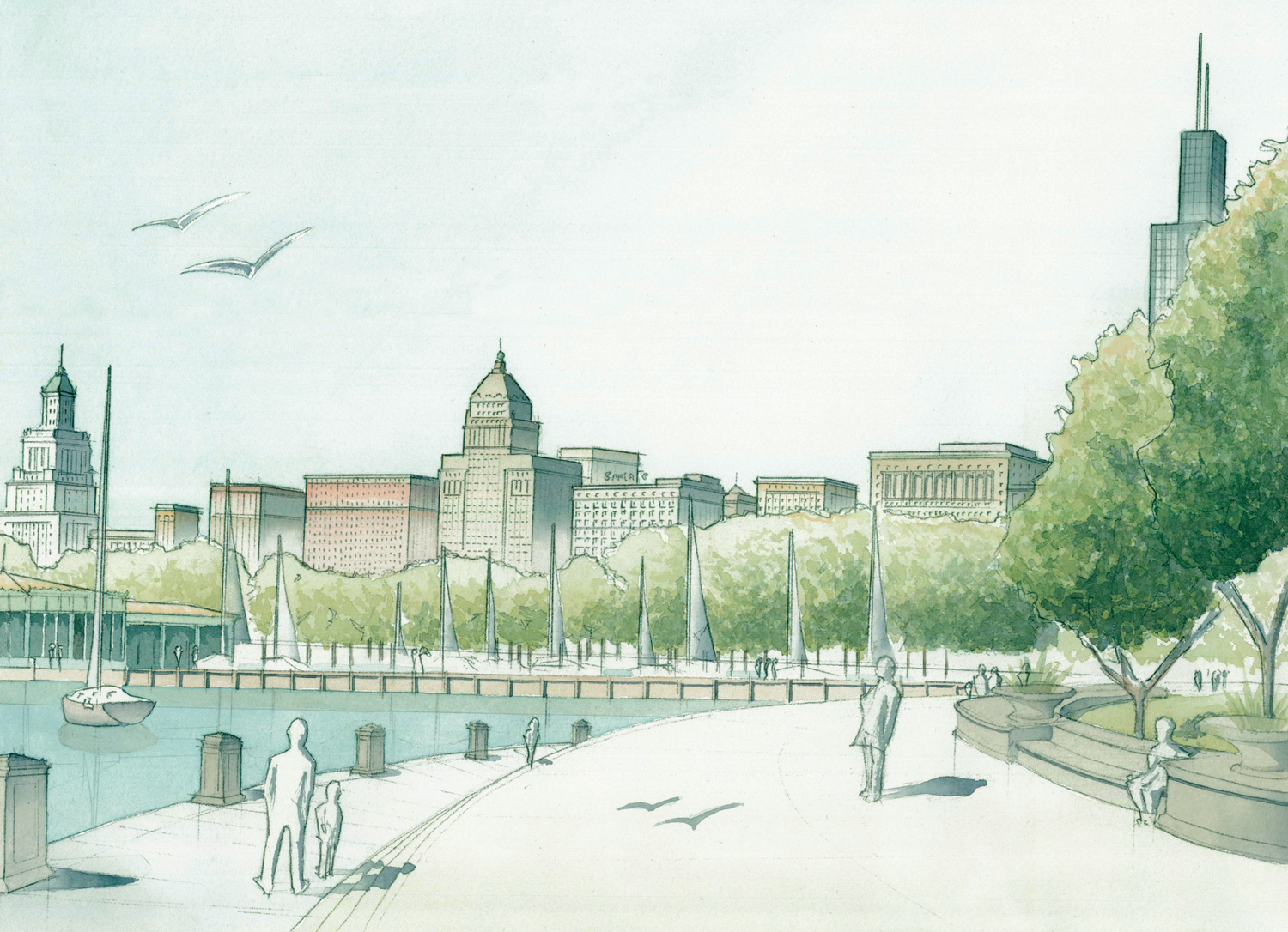
/2-16-View of Michigan Avenue looking north from Washington Street.jpg)
/2-17-Aerial view of Grant Park and Michigan Avenue looking northwest.jpg)
/2-18-View of Michigan Avenue looking south toward Twelfth Street (Roosevelt Road).jpeg)
/2-19-Proposed Twelfth Street Boulevard, looking southwest.jpg)
/2-20-Below-grade Railway Station proposal west of The Chicago River.jpeg)
/2-21-Above-grade Railway Station proposal west of The Chicago RiverPlate_CXXIII.jpg)
/2-22-Elevation of Grant Park and Harbor looking west.jpeg)
/2-23-Section through proposed Grand Axis of The City looking north.jpeg)
/2-24-Bird's-eye night-view of Harbor - Grant Park - Lagoons looking south.jpg)
/2-25-Plan of Chicago's Civic Center - Business Center - Grant Park - Yacht Harbor.jpg)
/2-26-Elevation of Civic Center Buildings looking west.jpeg)
/2-27-View of Civic Center Plaza and City Hall looking west.jpg)
/2-28-View of Chicago's Central Area looking east.jpg)
/3.1-01-Chicago 2109 Regional Waste and Storm Water Issues.jpg)
/3.1-02-Illinois Watersheds.jpg)
/3.1-03-Northeastern Illinois - Metro Chicago Watersheds (seven counties).jpg)
/3.1-04-Pre-19th Century Metro Chicago sub-continental divide.jpg)
/3.1-05-Chicago Sanitary and Ship Canal under construction (1896).jpg)
/3.1-06-Chicago Sanitary and Ship Canal (2007).jpg)
/3.1-07-Existing 2009 Metro Chicago reverse-flow watersheds.jpg)
/3.1-08-Metro Chicago April 2013 Flood - Ravenswood and Lawrence geyser (city).jpg)
/3.1-09-Metro Chicago April 2013 Flood - city underpass.jpg)
/3.1-10-Metro Chicago April 2013 Flood - sinkhole (city).jpg)
/3.1-11-Metro Chicago April 2013 Flood - Fox River (suburban Geneva).jpg)
/3.1-12-Metro Chicago April 2013 Flood - Oak Park-River Forest geyser (suburban).jpg)
/3.1-13-GLC 2012 restoration proposal to separate Great Lakes and Mississippi River Basins.jpg)
/3.1-14-Chicago 2109 Waste and Storm Water Management I.jpg)
/3.1-15-Chicago 2109 Waste and Storm Water Management II.jpg)
/3.1-16-Existing 2009 Metro Chicago Waste Water Treatment.jpg)
/3.1-17-Existing 2009 (reverse) City River Flows.jpg)
/3.1-18-Chicago 2109 Metro Chicago Waste Water Treatment.jpg)
/3.1-19-Chicago 2109 City River Flows.jpg)
/3.1-20-Chicago River South Branch Remediation at Bubbly Creek.jpg)
/3.1-21-Chicago 2109 Aerial of Chicago River South Branch at Damen Avenue looking west.jpg)
/3.1-22-Existing and Proposed Metro Chicago Waste Water Treatment.jpg)
/3.1-23-Existing and Proposed City River Flows - Water Treatment - Pervious Surfaces.jpg)
/3.1-24-Chicago 2109 Metro Chicago Watersheds.jpg)
/3.1-25-The United States as Watersheds I.jpg)
/3.1-26-The United States as Watersheds II - extended borders.jpg)
/3.2-01-Chicago 2109 Metropolitan Transportation and Land Use.jpg)
/3.2-02-Existing and Proposed Metro Chicago Mass Transit.jpg)
/3.2-03-Existing and Proposed Metro Chicago Major Thoroughfares.jpg)
/3.2-04-Metro Chicago Road and Rail circa 1850.jpg)
/3.2-05-Metro Chicago Road and Rail circa 1900.jpg)
/3.2-06-Metro Chicago existing Road and Rail (2009).jpg)
/3.2-07-Chicago 2109 Metro Chicago proposed Road and Rail.jpg)
/3.2-08-Metro Chicago existing Major Thoroughfares (2009).jpg)
/3.2-09-Chicago 2109 Metro Chicago proposed Major Thoroughfares.jpg)
/3.2-10-Basic Modes of Mass Transportation.jpg)
/3.2-11-Metro Chicago existing Mass Transit (2009).jpg)
/3.2-12-Chicago 2109 Metro Chicago proposed Mass Transit.jpg)
/3.2-13-Chicago 2109 City Transportation and Land Use.jpg)
/3.2-14-Existing and Proposed City of Chicago Mass Transit.jpg)
/3.2-15-Existing and Proposed City of Chicago Major Thoroughfares.jpg)
/3.2-16-City of Chicago Road and Rail circa 1850.jpg)
/3.2-17-City of Chicago Road and Rail circa 1900.jpg)
/3.2-18-City of Chicago existing Road and Rail (2009).jpg)
/3.2-19-Chicago 2109 City of Chicago proposed Road and Rail.jpg)
/3.2-20-City of Chicago existing Major Thoroughfares (2009).jpg)
/3.2-21-Chicago 2109 City of Chicago proposed Major Thoroughfares.jpg)
/3.2-22-Sample Sections of Re-urbanized Interstate Highways.jpg)
/3.2-23-City of Chicago existing Mass Transit (2009).jpg)
/3.2-24-Chicago 2109 City of Chicago proposed Mass Transit.jpg)
/3.2-25-Metro Chicago Rural Transportation and Land Use.jpg)
/3.2-26-Existing and Proposed Metro Chicago Rural Mass Transit.jpg)
/3.2-27-Existing and Proposed Metro Chicago Rural Major Thoroughfares.jpg)
/3.2-28-Metro Chicago Rural Road and Rail circa 1850.jpg)
/3.2-29-Metro Chicago Rural Road and Rail circa 1900.jpg)
/3.2-30-Metro Chicago existing Rural Road and Rail (2009).jpg)
/3.2-31-Chicago 2109 Metro Chicago proposed Rural Road and Rail.jpg)
/3.2-32-Metro Chicago existing Rural Major Thoroughfares (2009).jpg)
/3.2-33-Chicago 2109 Metro Chicago proposed Rural Major Thoroughfares.jpg)
/3.2-34-Metro Chicago existing Rural Mass Transit (2009).jpg)
/3.2-35-Chicago 2109 Metro Chicago proposed Rural Mass Transit.jpg)
/3.3-01-Satellite view of Metropolitan Chicago's seven counties (2009).jpg)
/3.3-02-Growth of Metropolitan Chicago (1939 - Homer Hoyt) -300x138.jpg)
/3.3-03-Metropolitan Chicago Land Use - Historic-Existing-Proposed.jpg)
/3.3-04-Existing and Proposed Metro Chicago Land Use.jpg)
/3.3-05-Metro Chicago Land Use circa 1857.jpg)
/3.3-06-Metro Chicago Land Use circa 1873.jpg)
/3.3-07-Metro Chicago Land Use circa 1899.jpg)
/3.3-08-Metro Chicago Land Use circa 1936.jpg)
/3.3-09-Metro Chicago existing Land Use (2009).jpg)
/3.3-10-Chicago 2109 Metro Chicago proposed Land Use.jpg)
/3.3-11-City of Chicago existing and proposed Land Use.jpg)
/3.3-12-City of Chicago existing Land Use (2009).jpg)
/3.3-13-City of Chicago existing Differentiated Land Use (2009).jpg)
/3.3-14-Chicago 2109 City of Chicago proposed Land Use.jpg)
/3.3-15-Chicago 2109 City of Chicago proposed Differentiated Land Use.jpg)
/3.3-16-Metro Chicago existing and proposed Rural Land Use.jpg)
/3.3-17-Metro Chicago existing Rural Land Use (2009).jpg)
/3.3-18-Chicago 2109 Metro Chicago proposed Rural Land Use.jpg)
/3.3-19-Chicago 2109 Metro Chicago proposed Differentiated Rural Land Use.jpg)
/3.4-01-Metro Chicago existing Energy Production (2009).jpg)
/3.4-02-Existing and Proposed Metro Chicago Industrial Land.jpg)
/3.4-03-Metro Chicago existing Industrial Land (2009).jpg)
/3.4-04-Metro Chicago existing Industrial Land and Freight Rail (2009).jpg)
/3.4-05-Metro Chicago existing Industrial Land - Freight Rail - Interstates (2009).jpg)
/3.4-06-Chicago 2109 Metro Chicago proposed Industrial Land.jpg)
/3.4-07-Chicago 2109 Metro Chicago proposed Industrial Land and Freight Rail.jpg)
/3.4-08-Chicago 2109 Metro Chicago proposed Industrial Land - Freight Rail - Interstates.jpg)
/3.4-09-Existing and Proposed City Industrial Land.jpg)
/3.4-10-Existing City Industrial Land (2009).jpg)
/3.4-11-Existing City Industrial Land and Freight Rail (2009).jpg)
/3.4-12-Existing City Industrial Land - Freight Rail - Interstates (2009).jpg)
/3.4-13-Chicago 2109 proposed City Industrial Land.jpg)
/3.4-14-Chicago 2109 proposed City Industrial Land and Freight Rail.jpg)
/3.4-15-Chicago 2109 proposed City Industrial Land - Freight Rail - Interstates.jpg)
/3.4-16-Existing and Proposed Metro Chicago Rural Industrial Land.jpg)
/3.4-17-Metro Chicago existing Rural Industrial Land (2009).jpg)
/3.4-18-Metro Chicago existing Rural Industrial Land and Freight Rail (2009).jpg)
/3.4-19-Metro Chicago existing Rural Industrial Land - Freight Rail - Interstates (2009).jpg)
/3.4-20-Chicago 2109 Metro Chicago proposed Rural Industrial Land.jpg)
/3.4-21-Chicago 2109 Metro Chicago proposed Rural Industrial Land and Freight Rail.jpg)
/3.4-22-Chicago 2109 Metro Chicago proposed Rural Industrial Land - Freight Rail - Interstates.jpg)
/3.5-01-World's Population Concentrated - Paris (55000 sq. mile) to Houston (3600 sq. mile).jpg)
/3.5-02-Metro Chicago circa 1936 at 10000 people per square mile.jpg)
/3.5-03-Metro Chicago circa 2009 at 3900 people per square mile.jpg)
/3.5-04-Chicago 2109 Metro Chicago at 13800 people per square mile.jpg)
/3.5-05-City of Chicago population density circa 1980.JPG)
/3.5-06-City of Chicago population density circa 2010.jpg)
/3.5-07-The decline of the City of Chicago's middle class from 1970 to 2012 (courtesy Daniel Hertz).gif)
/3.5-08-Chicago 2109 Metropolitan settlement types and densities.jpg)
/3.5-09-Chicago 2109 projected Metropolitan city and town densities.jpg)
/3.5-10-Chicago 2109 projected City settlement densities.jpg)
/3.5-11-Chicago 2109 projected Rural settlement densities.jpg)
/3.5-12-1943 Chicago highway proposal - Beyond Burnham (2009).jpg)
/3.5-13-1956 'Data Map' - Beyond Burnham (2009).jpeg)
/3.5-14-1966 Chicago Daily News coverage of regional design plans - Beyond Burnham (2009).jpeg)
/3.5-15-1968 NIPC 'Finger Plan' - Beyond Burnham (2009).jpg)
/3.5-16-2003 '2030 Metropolis Plan' from Chicago Metropolis 2020 - Beyond Burnham (2009).jpeg)
/3.5-17-2005 NIPC '2040 Regional Framework Plan' - Beyond Burnham (2009).jpg)
/3.6-01-Chicago 2109 greater historic center with proposed public spaces and buildings.jpg)
/3.6-02-Satellite view of Chicago's greater historic center (2009).jpg)
/3.6-03-2009 figure-ground of Chicago's greater historic center (existing).jpg)
/3.6-04-Chicago 2109 figure-ground of Chicago's greater historic center (proposed).jpg)
/3.6-05-Chicago Civic Center visions -- 1909 Plan of Chicago (L) - 2009 Circle Interchange (C) - Chicago 2109 (R).jpg)
/3.6-06-Chicago 2109 civic center with proposed public spaces and buildings.jpg)
/3.6-07-2009 figure-ground of existing conditions at proposed civic center site.jpg)
/3.6-08-Chicago 2109 figure-ground of proposed Chicago civic center.jpg)
/3.6-09-Existing and proposed views of Chicago's historic center looking west.jpg)
/3.6-10-Aerial view of Chicago's historic center looking west (existing).JPG)
/3.6-11-Chicago 2109 aerial view of historic center looking west (proposed).jpg)
/3.6-12-Chicago 2109 aerial view of proposed civic center looking east.jpg)
/3.6-13-Chicago 2109 aerial view of proposed civic center looking northwest.jpg)
/3.6-14-Chicago 2109 Columbian Exposition Boulevard (bottom) compared to other urban spaces.jpg)
/3.6-15-Plan of and Section through Columbian Exposition Boulevard looking north.jpg)
/3.6-16-Partial east elevation of Columbian Exposition Boulevard (top) - Columbian Exposition Boulevard looking north (bottom).jpg)
/3.6-17-Chicago 2109 proposed city hall at Congress and Halsted.jpg)
/3.6-18-Existing and proposed views of Chicago's historic center looking northeast.jpg)
/3.6-19-Existing and proposed views of Loop skyline looking northwest.jpg)
/3.6-20-Chicago 2109 proposed view of Oak Street Beach skyline.jpg)
/3.6-21-Existing view of Chicago's historic center looking west (2009).jpg)
/3.6-22-Chicago 2109 proposed view of Chicago's historic center looking west.jpg)
/3.6-23-Chicago 2109 proposed view of Chicago's historic center looking east.jpg)
/3.6-24-Preliminary sketch of proposed civic axis - sacred axis (Congress Street - Columbian Exposition Boulevard) crossing.jpg)
/3.6-25-Chicago 2109 Columbian Exposition Boulevard perspective looking north.jpg)
/3.6-26-Chicago 2109 proposed view of historic center looking northeast (I).jpg)
/3.6-27-Chicago 2109 proposed view of historic center looking northeast (II).jpg)
/3.6-28-Chicago 2109 proposed view of Loop skyline looking northwest from Chicago's lakefront museum campus.jpg)
/3.7-00.1-Metro Chicago Representative Projects.jpg)
/3.7-01.1-Wayne 2009 Existing Conditions.jpg)
/3.7-01.2-Wayne 2109 Master Plan.jpg)
/3.7-01.3-Wayne 2109 Regulating Plan.jpg)
/3.7-02.1-Prairie Crossing Proposed Master Plan.jpg)
/3.7-02.2-Prairie Crossing Market Hall South Elevation.jpg)
/3.7-02.3-Prairie Crossing looking NE from SW Metra station.jpg)
/3.7-02.4-Prairie Crossing looking SW from NE Metra station square porch.jpg)
/3.7-02.5-Prairie Crossing Market Hall North Elevation.jpg)
/3.7-02.6-Prairie Crossing looking SW from NE Metra station square terrace.jpg)
/3.7-02.7-Prairie Crossing looking south from NE Metra station.jpg)
/3.7-02.8-Prairie Crossing Market Hall West Elevation.jpg)
/3.7-03.1-Lewis University Existing Conditions.jpg)
/3.7-03.2-Lewis University Proposed Master Plan.jpg)
/3.7-03.3-Lewis University Proposed Regulating Plan.jpg)
/3.7-03.4-Lewis University Campus and Village from SE.jpg)
/3.7-03.5-Lewis University looking NE.jpg)
/3.7-04.1-Fox Lake Existing Conditions.jpg)
/3.7-04.2-Fox Lake Proposed Master Plan.jpg)
/3.7-04.3-Fox Lake Proposed Regulating Plan.jpg)
/3.7-04.4-Fox Lake existing town center from south.jpg)
/3.7-04.5-Fox Lake proposed town center plan.jpg)
/3.7-04.6-Fox Lake proposed town center from southwest.jpg)
/3.7-06.1-Lake Forest Market Square Existing Conditions.jpg)
/3.7-06.2-Lake Forest Market Square Proposed Expansion (left).jpg)
/3.7-06.3-Howard Van Doren Shaw admires the addition.jpg)
/3.7-06.4-Lake Forest Market Hall east elevation.jpg)
/3.7-06.5-Lake Forest Market Hall west elevation.jpg)
/a-Proposed Wheaton Neighborhoods diagram.jpg)
/b-Proposed Wheaton Landscape Weave diagram.jpg)
/c-Proposed Wheaton Transit diagram.jpg)
/3.7-07.1-Wheaton Proposed Regulating Plan.jpg)
/3.7-07.2-Wheaton Proposed Master Plan.jpg)
/3.7-07.3-Main Street south (Wheaton).jpg)
/3.7-07.4-Illinois & Naperville Streets looking west (Wheaton).jpg)
/3.7-08.1-Southwest Interventions.jpg)
/3.7-08.2-Blue Island Existing Conditions.jpg)
/3.7-08.3-Blue Island Proposed Interventions.jpg)
/3.7-08.4-Blue Island aerial view looking northeast.jpg)
/3.7-09.1-Tinley Park Existing Conditions.jpg)
/3.7-09.2-Tinley Park Proposed Interventions.jpg)
/3.7-09.3-Tinley Park aerial view looking southeast.jpg)
/3.7-10.1-Joliet Existing Conditions.jpg)
/3.7-10.2-Joliet Proposed Interventions.jpg)
/3.7-10.3-Joliet aerial view looking southeast.jpg)
/3.7-11.1-South Chicago-USX Existing Conditions I.jpg)
/3.7-11.2-South Chicago-USX Proposed Regulating Plan.jpg)
/3.7-11.3-South Chicago-USX existing conditions II.jpg)
/3.7-11.4-South Chicago-USX proposed conditions.jpg)
/3.7-12.1-Englewood Existing Conditions.jpg)
/3.7-12.2-Englewood Proposed Master Plan.jpg)
/3.7-12.3-Englewood Proposed Regulating Plan.jpg)
/3.7-12.4-Existing 63rd & Halsted (Englewood) looking north.jpg)
/3.7-12.5-Proposed 63rd & Halsted (Englewood) looking northwest.jpg)
/3.7-13.1-49th & Western Existing Conditions.jpg)
/3.7-13.2-49th & Western Proposed Master Plan.jpg)
/3.7-13.3-49th & Western Proposed Regulating Plan.jpg)
/3.7-13.4-Existing 49th & Western looking north.jpg)
/3.7-13.5-Proposed 49th & Western looking northwest.jpg)
/3.7-14.1-Armour Field South Side Context.jpg)
/3.7-14.2-Armour Field Concept Plan.jpg)
/3.7-14.3-Armour Field Site Plan.jpg)
/3.7-14.4-Armour Field Exterior Perspective.JPG)
/3.7-14.5-Armour Field Interior Perspective.JPG)
/3.7-14.6-Armour Field South Elevation.jpg)
/3.7-14.7-Armour Field East elevation.jpg)
/3.7-14.8-Armour Field Section looking east.jpg)
/3.7-14.9-Armour Field looking northeast.jpg)
/3.7-14.10-Armour Field looking north.jpg)
/3.7-14.11-Comiskey Park at 35th & Shields looking northwest.jpg)
/3.7-15.1-Bronzeville Existing Conditions.jpg)
/3.7-15.2-Bronzeville Existing Figure-Ground.jpg)
/3.7-15.3-Bronzeville Proposed Master Plan.jpg)
/3.7-15.4-Bronzeville Proposed Regulating Plan.jpg)
/3.7-15.5-Gwendolyn Brooks Plaza (Bronzeville) looking southeast.jpg)
/3.7-16.1-South Branch Existing Figure-Ground.jpg)
/3.7-16.2-South Branch Proposed Master Plan.jpg)
/3.7-16.3-South Branch looking northwest.jpg)
/3.7-16.4-South Branch looking southwest.jpg)
/3.7-16.5-South Branch Overall Area Regulating Plan.jpg)
/3.7-17.1-Near West Existing Conditions.jpg)
/3.7-17.2-Near West Existing Figure-Ground.jpg)
/3.7-17.3-Near West Proposed Master Plan.jpg)
/3.7-17.4-Near West Proposed Regulating Plan.jpg)
/3.7-17.5-Near West Proposed Block Structure.jpg)
/3.7-17.6-Near West looking northwest.jpg)
/3.7-18.1-North Branch existing at Diversey looking southeast.jpg)
/3.7-18.2-North Branch Proposed Interventions I.jpg)
/3.7-18.3-North Branch proposed at Diversey looking southeast.jpg)
/3.7-18.4-North Branch existing at Fullerton looking southeast.jpg)
/3.7-18.5-North Branch Proposed Interventions II.jpg)
/3.7-18.6-North Branch proposed at Fullerton looking southeast.jpg)
/3.7-18.7-North Branch existing at Armitage looking southeast.jpg)
/3.7-18.8-North Branch Proposed Interventions III.jpg)
/3.7-18.9-North Branch proposed at Armitage looking southeast.jpg)
/3.7-19.1-Uptown Existing Figure-Ground.jpg)
/3.7-19.2-Uptown Proposed Interventions.jpg)
/3.7-19.3-Uptown Proposed Regulating Plan.jpg)
/3.7-19.4-Uptown Existing Conditions.jpg)
/3.7-19.5-Uptown proposed looking northwest.jpg)
/3.7-20.1-Loyola University Neighborhood context.jpg)
/3.7-20.2-Loyola Neighborhood looking south.jpg)
/3.7-20.3-Loyola University Proposed Interventions.jpg)
/3.7-20.4-Loyola University looking south.jpg)
/3.7-20.5-East elevation of Loyola Information Commons (IC) counter-proposal.jpg)
/3.7-20.6-Loyola IC plan & west elevation.jpg)
/3.7-21.1-Neumannville Existing Conditions.jpg)
/3.7-21.2-Neumannville Proposed Master Plan.jpg)
/3.7-21.3-Neumannville looking northwest.jpg)
/3.7-21.4-Site plan and east elevation of Neumannville Church and School.jpg)
/3.7-21.5-North elevation of Neumannville Church and School.jpg)
/3.7-22.1-Chicago Circle Existing Conditions.jpg)
/3.7-22.2-Chicago Circle proposed conditions looking northwest.jpg)
/3.7-22.3-Chicago Circle Proposed Figure-Ground.jpg)
/3.7-22.4-Chicago Circle proposed interventions looking east.jpg)
/3.7-22.5-Loop & Grant Park Existing Figure-Ground.jpg)
/3.7-22.6-Loop & Grant Park Proposed Figure-Ground.jpg)
/3.7-22.7-Loop & Grant park looking northwest.jpg)
/3.7-22.9-Schematic study of neighborhood centers.jpg)
/3.7-22.10-Streeterville Existing Figure-Ground.jpg)
/3.7-22.11-Streeterville Proposed Figure-Ground.jpg)
/3.7-22.12-Sample draft Streeterville code page.jpg)
/3.7-22.13-Streeterville perspective looking south.jpg)
/3.7-22.14-Historic Center Plans existing (L) & proposed (R).jpg)
/3.7-22.15-Historic Center Parks existing (L) & proposed (R).jpg)
/3.7-22.16-Chicago Circle Existing Figure-Ground.jpg)
/3.7-22.17-Chicago Circle Proposed Figure-Ground.jpg)
/3.7-22.18-Neighborhood square study looking northeast.jpg)
/3.7-22.19-Congress Parkway study looking west.jpg)
/3.7-22.20-Grand Civic Axis study looking west.jpg)
/3.7-22.21-City Hall east elevation study.jpg)
/3.7-23.1-Chicago Classicism.jpg)
/3.7-23.2-Olympic Village Welcome Center (Near South).jpg)
/3.7-23.3-Proposed Olympic Village Site Plan (Near South).jpg)
/3.7-23.4-Welcome Center Ground Floor Plan (Near South).jpg)
/3.7-23.5-Welcome Center East Elevation (Near South).jpg)
/3.7-24.1-LaFox (Kane County) 1857.jpg)
/3.7-24.2-LaFox (Kane County) 2009.jpg)
/3.7-24.3-LaFox 2009.jpg)
/3.7-24.4-Metro Chicago 2109.jpg)
/3.7-24.5-LaFox (Kane County) 2109.jpg)
/3.7-24.6-Kane County 2109 Land Value Tax.jpg)
/3.7-24.7-LaFox Existing and Proposed Conditions.jpg)
/3.7-24.8-LaFox Plan and Aerial.jpg)
/3.7-24.9-Plan of LaFox.jpg)
/3.7-24.10-LaFox aerial looking south.jpg)
/3.7-24.11-LaFox neighborhood library and plaza.jpg)
/3.7-24.12-LaFox Boulevard and Town Hall.jpg)
/3.7-24.13-LaFox Constructed Wetlands Wastewater Treatment.jpg)

Pace Phil Spector, pace Fenway Faithful, pace Pink Floyd (we do need an education), a partial selection of After Burnham project images.